
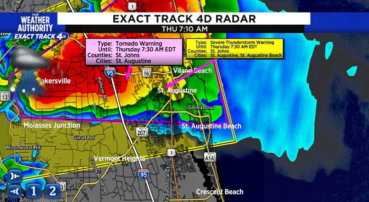
Tornado Warning in St. Johns county until 7:30 am

A severe thunderstorm with tornado potential was located near Picolata, or 11 miles southeast of Green Cove Springs, moving east at 25 mph.
HAZARD…60 mph wind gusts.
SOURCE…Radar indicated.
IMPACT…Expect damage to roofs, siding, and trees.
Locations impacted include Saint Augustine, World Golf Village, Saint Augustine Beach, South Ponte Vedra, Vilano Beach, Saint Augustine South, Picolata, SaintAugustine Shores, Anastasia and Bakersville.
Waking up to the rumble of thunder and the sound of rain. After a stormy start some flooding will be possible across southern Charlton, northern Duval, Nassau and southern Camden counties through sunrise. Scattered showers with storms will be possible this afternoon before decreasing late this afternoon, evening.
Where did this rain come from? https://www.news4jax.com/weather/2022/04/07/tornado-warning-for-camden-county-georgia-is-over/
Ad
Thursday: Showers with storms, slow clearing through the afternoon, 50-80 percent. Wake up temperatures in the 60s to low 70s. Afternoon highs in the 70s for SE GA, upper 70s to low 80s for NE FL. Wind: West 15-20 mph. Clear and cooler overnight.
Friday: Sunny, cool and windy. Moring lows in the upper 40s to 50s. Afternoon highs in the upper 60s to low 70s. Wind WSW 15-20 with stronger gusts. A chilly breeze continues overnight.
Looking ahead: Windy and sunny Saturday. Less wind with lots of sun Sunday. Below normal temperatures Friday through Monday.
7am 73
8am 74
9am 75
10am 76
11am 79
12pm 81
3 pm 82
5pm 80
8pm 72
10pm 68
11pm 65
Sunrise: 7:09 am
Sunset: 7:49 pm
Copyright 2022 by WJXT News4Jax – All rights reserved.
Post source: News 4jax